Exiting the Subway and Finding Your Way 10-16-2007
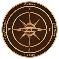
 All too often, exiting a subway station and getting your bearings can be a bit disorienting, especially in New York City’s grid. Gothamist.com reports on a new wayfinding system, developed by New York City’s Department of Transportation and the Grand Central Partnership, to assist people on finding the right way upon exiting a subway station. It is about to be tested around the MTA’s Grand Central Station subway exits. The sidewalk decals feature a compass image displaying which street is in what direction.
It’s interesting to see that the decals will not be placed in actual N,S,W,E orientation (Manhattan actually points Northeast), but placed according to what New Yorkers correlate to North and South (i.e., Uptown and Downtown).
It’s a great start, but now we just need the subway map, local street map, and “Next Train” notifications posted at street level. Not too mention the one shortcoming of the MTA’s subway map, depicting which trains are express and which are local. Even I still have a bit of trouble remembering which of the N,R,W,Q trains are express.